

Rawlins Copper-Gold Project
Approximately 20km west of Mt Weary (and 20km northwest of Cannindah Resources Ltd.’s adjoining Mt Cannindah Project), a number of copper-gold prospects occur over an area of approximately 5km by 3km comprising the:
- Rough Gully Prospect
- Copper Knob Prospect and
- Eastern Star Prospect.
These three Prospects are clustered together on the margin of a significant annular feature in regional magnetic datasets.
The aerial magnetic anomalies are coincident with several zones of surface copper-gold anomalism returned in surface sampling and mapping completed by the Company in the 18 month period prior to listing. The Rough Gully magnetics feature is considered to be a buried intrusion not previously recognised. In addition to anomalism in systematic soil survey work, better rock chip sampling results across the Rawlins Project area include:
- 31.1g/t Au, 56g/t Ag, 0.6% Cu
- 9.55g/t Au, 59.2g/t Ag, and 2.84% Cu
- 1.12g/t Au, 14.6g/t Ag, and 10.7% Cu
The Eastern Star Prospect is a separate sub-circular magnetic feature with a linear zone in its northern section that extends past the main circular shape. Recent trenching at Eastern Star has provided better intercepts including:
- 5.4 m @ 0.98 g/t Au, 8 g/t Ag, 0.17% Cu,
Including 1.5 m @ 2.79 g/t Au, 8 g/t Ag, 0.83% Cu. CH21ES01 - 1.2 m @ 3.49 g/t Au, 11 g/t Ag, 0.73% Cu – CH21ES02
- 1.0 m @ 8.94 g/t Au, 64 g/t Ag, 0.72% Cu – CH21ES03
- 3.5 m @ 0.98 g/t Au, 13 g/t Ag, 0.42% Cu,
Including 1.2 m @ 1.29 g/t Au, 25 g/t Ag, 0.74% Cu – CH21ES04

Figure 1: Rawlins Project – total magnetic intensity image with structural and alteration interpretation overlain with locations of reported soil results.
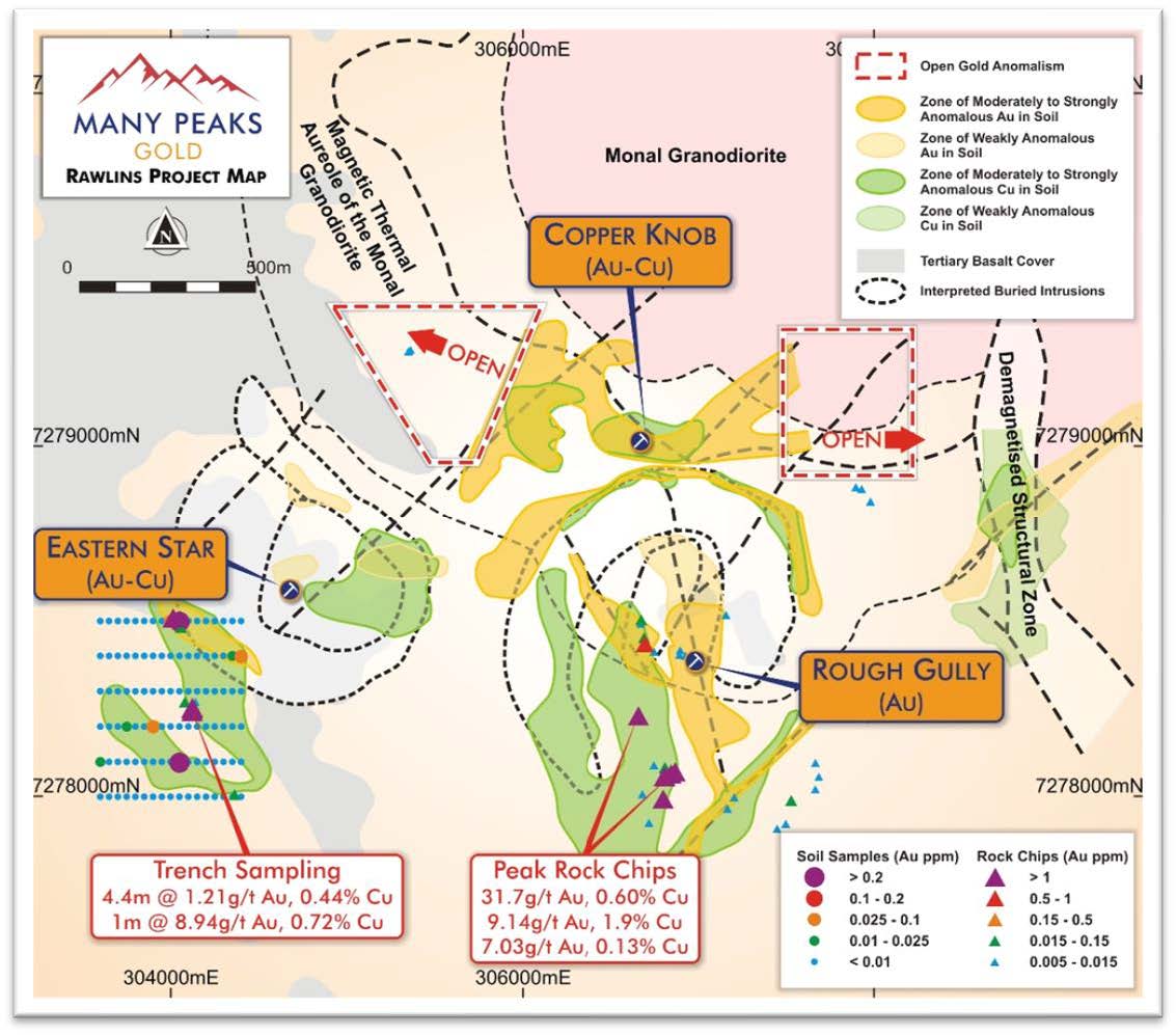
Figure 2: Rawlins Project – Prospect zones based on integrated geophysical and soil geochemistry datasets.